AIRSPACE
Pilots have an obligation to check for airspace prior to flight. The local summaries below were correct at the time of publication.
Updated airspace (and radio frequency) information is published by Airways NZ, and is the primary reference. This info is available for free and is well presented on maps at https://gopreflight.co.nz
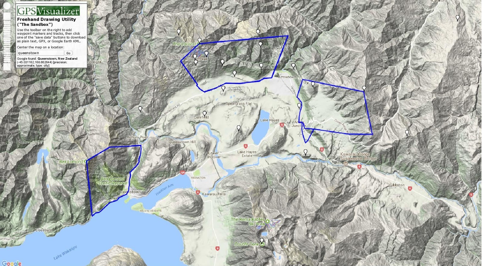
In recent years air traffic into the Queenstown area has risen dramatically which has necessitated restrictions on paragliding and hang-gliding operations in the Wakatipu Basin. There has been much consultation with Airways and Air Traffic Authorities which has resulted in several unique flying zones close to Queenstown. Each of these three zones sit within the busy Queenstown Control Zone. Most pilots flying xc work with Ch 33 UHF (477.225MHz).
SKYLINE GONDOLA
The most accessible site to fly is the ‘Skyline’ which is noticeably visible from the town of Queenstown and accessible by the ‘Gondola’. This is an extremely sensitive site due to its proximity to built-up areas and flight paths for commercial aircraft into, and out of, Queenstown Airport. Operations in this General Aviation Area (G756) are covered by a Memorandum of Understanding (MOU) between the Queenstown Airport and the SHGPGC.
All pilots must be compliant with this MOU in order to fly in G756 and to that end all pilots must be licensed, accredited and certified to fly here. No exceptions!
See Skyline Gondola page for more information.
The maximum altitude is 4500ft.
The landing areas are critical and limited.
Changeable and fickle winds can make this quite a demanding site to fly.
Make sure you are adequately briefed by local pilots before flying this site.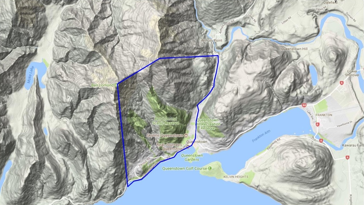
CORONET PEAK
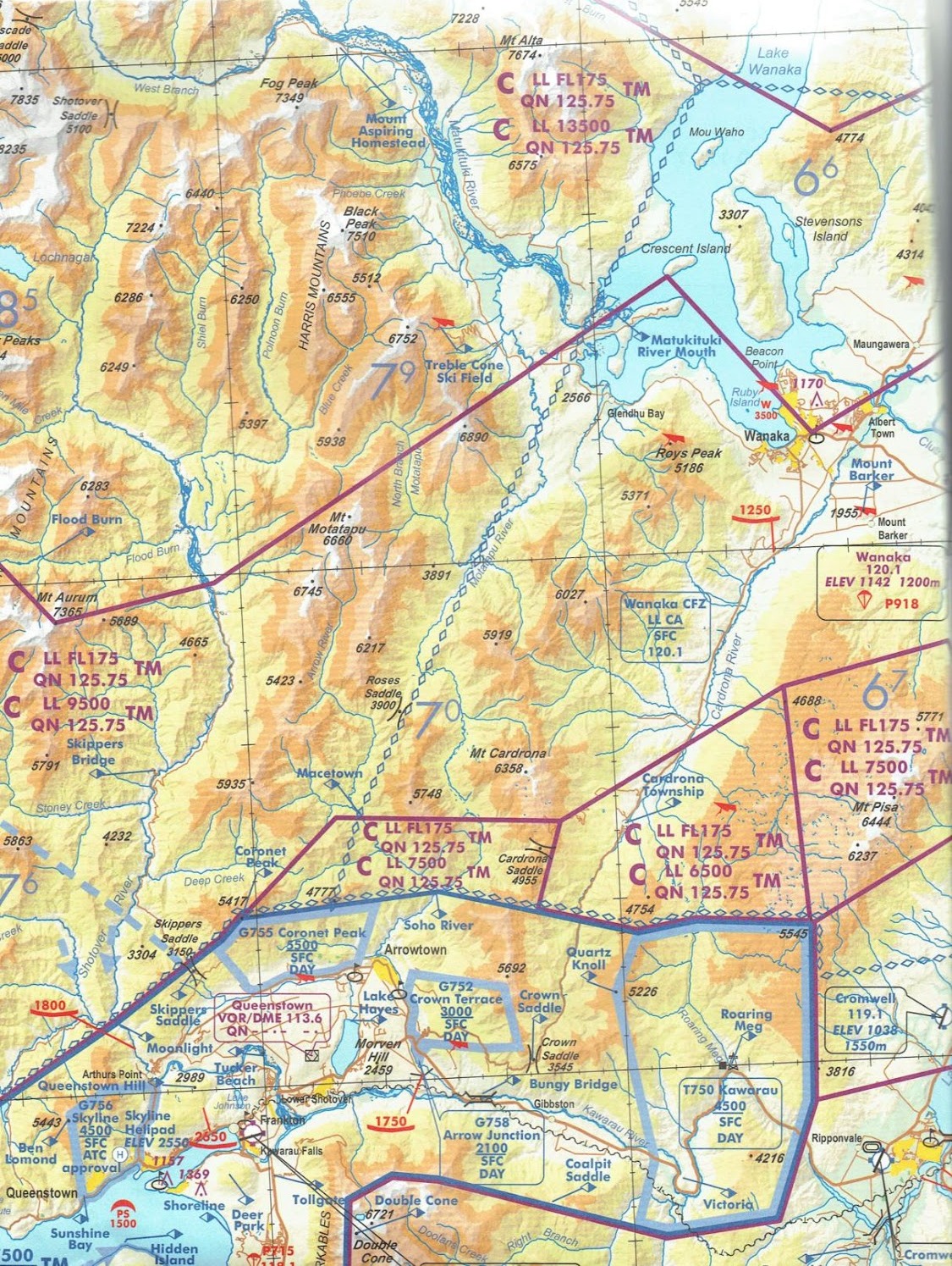
Coronet Peak, some 16km from Queenstown, is the main flying site for paragliders and hang-gliders in the Wakatipu Basin. The airspace, G755, is bounded in the west pretty much by a line from the ridge above the western zig-zag on the access road, south to Malaghans Rd, then east along Malaghans Rd which defines the southern boundary to Manse Rd near Arrowtown, thence a line north-east towards Big Hill spur and again a line west, just south of Brow Peak, to Coronet Peak itself and back to the western boundary.
The maximum altitude is 5500ft, which is very close to the same altitude as the summit of Coronet Peak. Do not exceed 5500ft as civil and commercial traffic fly very close to this limit on their descent into Queenstown airport.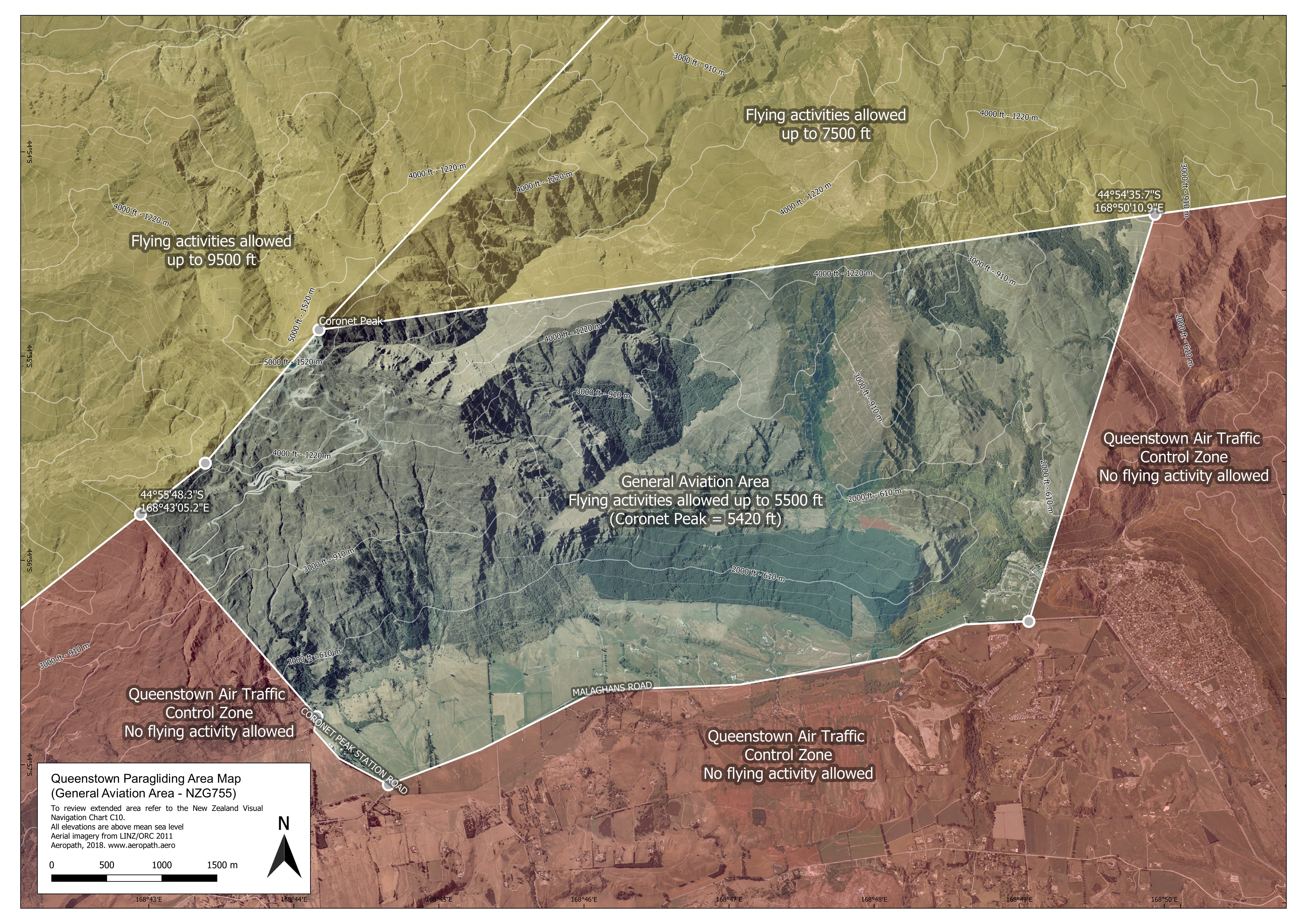
THE CROWN TERRACE
The ‘Terraces’ are primarily a ridge soaring site flown mostly in the for late afternoon or evening as it takes the north-westerly winds that blow over from Coronet Peak. The airspace, G753, has a maximum altitude of 3000ft and since the launch height is 2000ft, the ceiling is not very high above take-off. It is rare that thermals are flown here.
The western edge of the airspace is the Highway / Arrowtown Rd extending north to around Mt Beetham where there is a distinctive pine tree very close to the northern boundary. Of concern to the south is the arrival flight path for Runway 23 at Queenstown.
The small area of G758 was recently established as the landing field is across the highway and to the left of takeoff, but as it is towards the flight path an upper limit of 2100ft is set which means that once you leave ridge height to the left of take-off you are pretty much committed to land.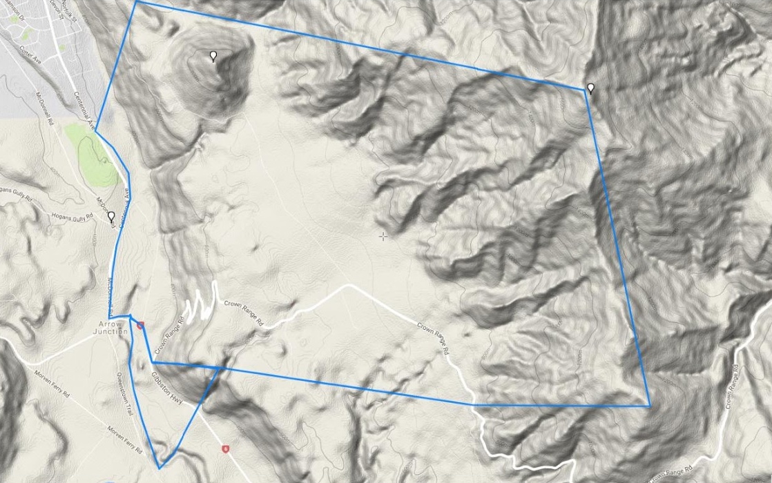
FLYING NORTH from QUEENSTOWN and WANAKA
It is a beautiful and challenging endeavour to fly north from Coronet Peak towards Treble Cone and Wanaka. Behind the main Coronet ridge the airspace ceiling rises to 7500ft. If tracking towards Brow Peak to the east of Coronet Peak once you pass the distinctive shale slide you can climb to 7500ft and over Brow peak the ceiling is 7500ft which it remains until passing an east-west line about level with the low peak of Mt Soho. There-after the airspace rises to 9500ft. Note that over Cardrona the ceiling is 6500ft.
At Treble Cone itself the airspace ceiling is 13500ft however, due to the proximity to Wanaka airfield and its abundance of helicopter and light aircraft traffic, flying in the vicinity of the Motatapu and Matukituki Valleys and towards Wanaka especially can be particularly challenging. Light aircraft traffic find it very difficult to see paragliders and hang-gliders whilst in flight. There are also considerable helicopter operations in and around Treble Cone. When planning xc from Treble Cone pilots are urged to carry airband radios for at least a good listen-out to transmit when possible.