CORONET PEAK
Coronet Peak is the main flying site at Queenstown.
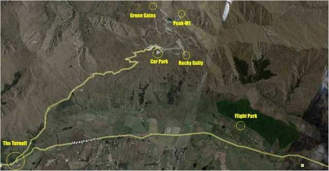
There are two main takeoffs: ‘The Carpark’ and ‘Rocky Gully’
[smartslider3 slider=2]
ACCESS
The Coronet Peak takeoffs are 16 Km from Queenstown. Head East from Queenstown towards Arrowtown via Malaghans road turn then turn left onto Skippers Road, also known as the Coronet Peak Ski Field access road.
NOTE: the dirt access road from the Base Station to Rocky Gully is a private road. Pilots are permitted to use this road and must respect this privilege.
Often pilots meet at the landing field: ‘The Flight Park’, on the northside of Malaghans road towards Arrowtown for a lift to takeoff and to be briefed by local pilots on flying suitability.
 Airspace
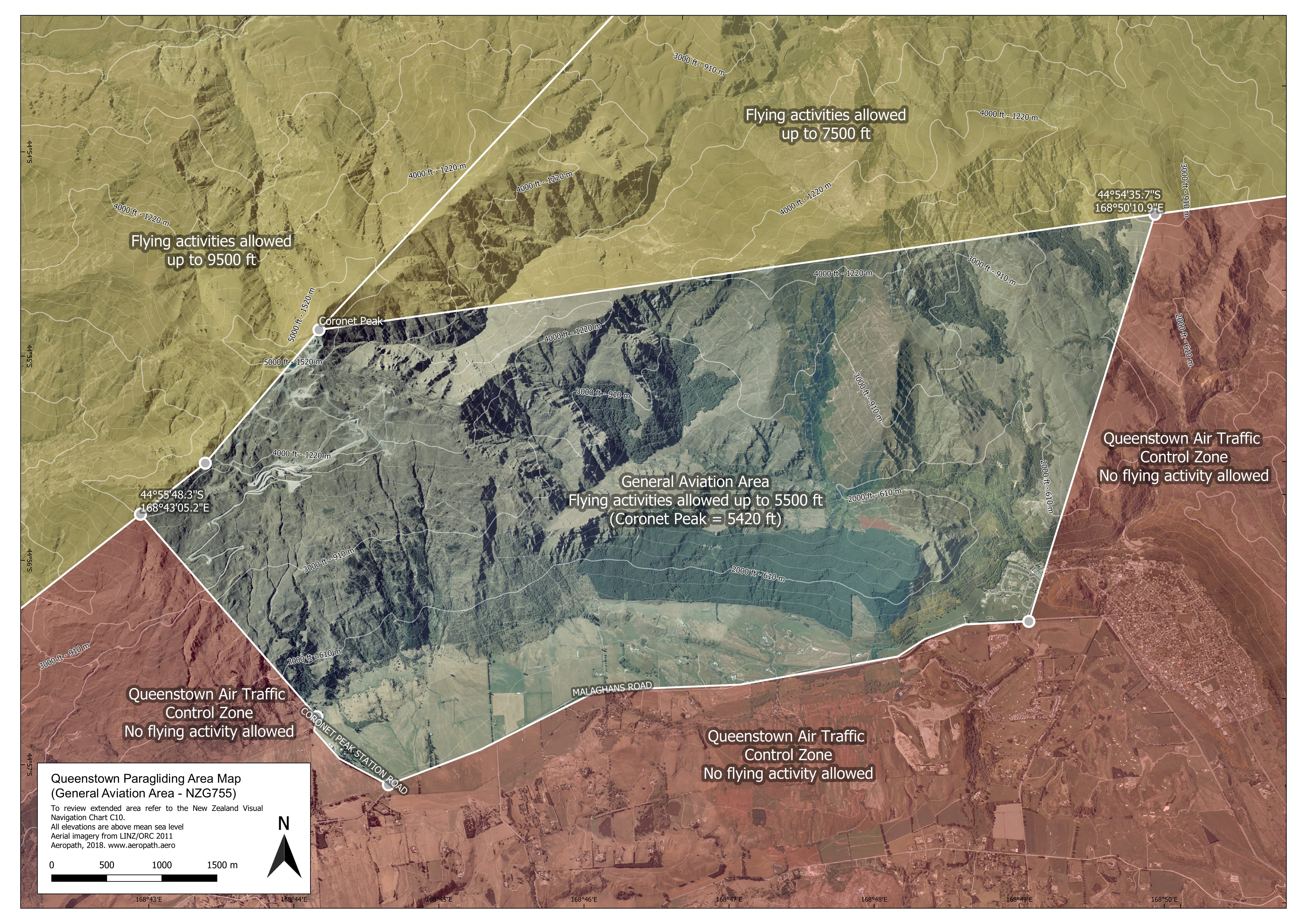
There are strict airspace restrictions due the proximity to Queenstown airport.
This airspace, G755, is a General Aviation area located within the Queenstown Tower Control Zone.
The ceiling is 5500ft AMSL.
NOTE: the summit of Coronet Peak is 1650m / 5400ft !
Essentially, the western boundary is defined by the hairpins on the Coronet access road; do not fly south of Malaghans road and do not fly further east than the forestry block ridge although the airspace there is a little further east at Manse Road.
 Weather
Coronet Peak is one of the most flyable sites in the region due to its mountain protection.
‘Holfuy – New Zealand’ (http://holfuy.com.) has four weather stations for this site, including one for the Flight Park landing area. Also check the Metservice website: (metservice / southernlakes)
As always, check with local pilots. However, Coronet Peak tends to be Southwest in summer and North in winter. In summer, it can be a bit deceptive and there’s two common trends to watch for. “The Southerly” and the “NorWester”
The NorWester can really bite you! It can switch quickly and violently. The Coronet Peak flying area is wind-shadowed from the mountain peak in a NorthWest flow. Especially as in summer the takeoffs are 1/3rd of the way down the hill.
However, not all NW days will have the switch! Often it is possible to fly all day long under a high level NW wind. The NW tends to descend ‘onto the flying zone’. It’s important to keep an eye out for the windsocks on the ridgeline. Do chat with the tandem operators for a weather brief.
An indecisive windsock on a strong upper level NW day is not a good sign. It can mean you’re in the “mixing layer”… the transition between being ‘sheltered’ and ‘smacked’! This is especially true if you’re getting some strongish down cycles.
Beware of dust devils on takeoff. They’re lee-side thermals developing in the predominant upper NW and commonly occur right before things switch.
The Southerly is a mix of a high level southerly flow and the sea-breeze effect from the Lake Wakatipu. It is the predominant valley wind / sea breeze coming from the south. It can come in hard and fast! Keep a look out for wind indicators on the lake in the distance to the south to avoid being caught out.
If the southerly remains light, Coronet Peak is a magical place to fly. However, if the southerly flow and the sea-breeze mix it can come in very strong, and flying can get very ugly!
Being part seabreeze, the strong southerly will increase markedly in the Flight Park before it is evident on takeoff. It is possible to top-land at Coronet Peak and sometimes this may be the best option, but with caution, in strong southerlies. The airport and Skyline-Gondola will blow out first in a southerly.
Sometimes, as a Westerly takes effect, it can cause an “Easterly Suck”. This can prevent gliding into wind to Flight Park from CarPark #4. Rocky Gully is the better option for take-off in these conditions.
 Take off
The primary takeoffs are astro-turfed at the Carpark #4 (elevation: 1135m / 3720ft ) and Rocky Gully ( elevation: 1180m / 3870ft )
The Carpark is not suitable for speed wings due to the glide to the Flight Park landing field.
Rocky Gully also requires caution and awareness of the required glide to the Flight Park (3km)
In the winter, the primary takeoffs area the top of the Main M1 chairlift and at the top of the Greengates chair lift. A special chairlift certification is required to use the chairlifts in winter.
The ski-field is very sensitive to low flying within its boundaries.
 Landing
The primary landing field is the ‘Flight Park’. The ‘Flight Park’ is on the north side of Malaghans road 16km from Queenstown.
At present, two Paragliding Instructor Schools ( ‘Infinity Paragliding’ and ‘Extreme Air’ ) operate from this field. Do consult them for a site briefing.
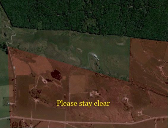
The Flight Park is the ONLY permissible place to land unless for emergencies.
There are some other very limited options for landing. Please speak to local pilots, particularly the Instructor School managers, for a briefing to find out where these are.
Some of the local landowners vehemently oppose any landings at anytime for any reason. In the past police have become involved and legal action has resulted. All emergency out landings must be reported to a local SHGPGC pilot.
The Flight Park is privately owned, there is a small cafe at the Flight Park
Address: 793 Malaghans Rd
Cafe telephone: 03 442 1586.
Landings fees apply. These may be obtained, preferably, online (www.flightpark.co.nz) or there is a collection box on the external wall at the cafe.
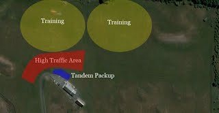
This is a “High Traffic Area” and the landing areas can be very busy with both novice, experienced, tandem and hang glider pilots. The hang glider pilots have their own unique landing characteristics! Hang gliders are fast and are less manoevrable.
There is a dedicated ‘pack-up’ zone by the cafe. After landing you must go there to pack up.
SUMMER FLYING FROM THE SUMMIT
The new summertime flying guidelines are:
Take offs will be from the normal winter take off sites only please. ie. on the North side of the summit taking off towards the West, North or East OR taking a short walk to Greengates top along the chimney ridgeline or down the M1 and up Tuck to take off facing predominately South but also SE to NW.
No NE TO E launches at Greengates as this would take you over our main reservoir. Same as for flying in winter.
No foot passenger policy will apply in summer for paragliding foot passengers. Only the Gondola cabins are to be used for up and down load. However it will be required in the winter due to the fact you may wish to use the Greengates chairlift.
We ask that all winter operating safety guidelines are followed, particularly flying safely around the operating lift line of the Coronet Express.
Note that guided walks will be taking place on the back ridge to the North of the summit, so please respect any hikers and their safety and conversely they will respect you with advice from our guides.
NZSKI will always assist you with wind direction and speed info from the top before loading the lift if you request it, and we advise you to use the Holfuy site for Coronet Peak summit winds (although based on Greengates ridge top) to assist you also.
NZSKI will never advise you on conditions for flying as this is not our skill base, this is solely down to you as the pilot under NZHGPA and CAA procedures.
We understand that pilots may wish to launch to the South from the top of the Coronet Express lift but due to the hazards associated with this we unfortunately cannot allow this. ie. proximity to operational liftline, mountain bikers on trail, hikers, mountain vehicles.


