TREBLE CONE
Treble Cone (TC) is the primary flying site in Wanaka. It is also the best site within the Southern region for cross country flying as it gives access to good terrain, generally with road retrieves.
Treble Cone has become a popular launch for speed flying in the quieter morning air due to the steepness of the terrain. Cross country pilots like the relative lack of airspace restrictions, proximity to the mountains and road access. The site faces North East so starts to thermal relatively early in the morning.
[smartslider3 slider=6]
This is mountain flying. The peaks are high. It can be cold and turbulent. Be wary of flying in the lee of ridges and spurs. Be wary of valley winds, the seabreeze and venturi effect.
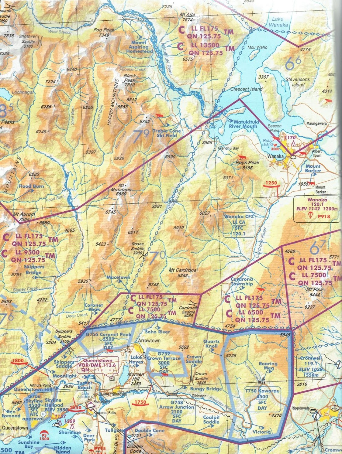
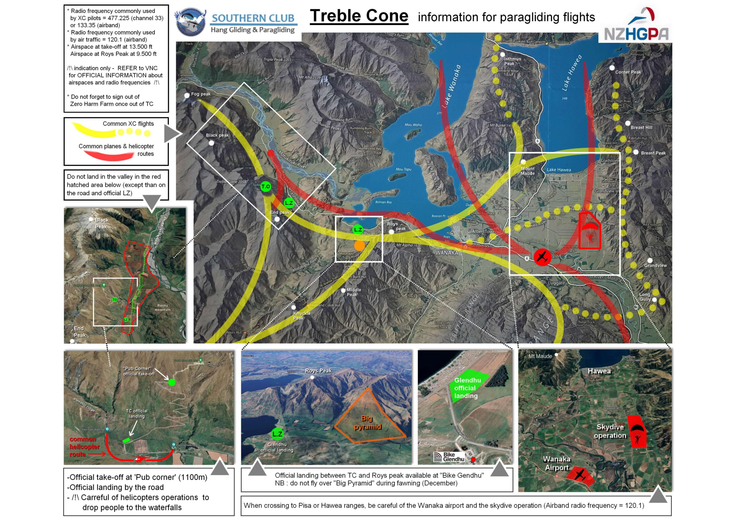
Commonly, xc pilots fly either up the Matukituki valley (mountains) or towards Wanaka and the flatter lands beyond. It is also possible to fly towards Queenstown and Glenorchy, though check the airspace and topo maps and be prepared for a LONG walk if you land out.
ACCESS
The Treble Cone access road is 22km from Wanaka along the Mt Aspiring Rd past Glendhu Bay and indicated by the big timber arch (with the Treble Cone sign) on the left. Park your car on the right by the fence with the windsocks. Meet the locals here as normally pilots car-pool to proceed further. There is a dirt road only access from this point. It is steep and rutted but normally drive-able with a 2WD.
SUMMER ACCESS
Please visit https://www.treblecone.com to access the gate code, bear in mind that this code will change fairly regularly.
Leave all other gates as you find them. There is often stock on the road and the gates are used to manage them. There is a 50km/hr speed limit on the access road. Please respect this – treat it like a public road even if the gate is locked.
– Please obey all closures and signage.
– Please close the bottom gate behind you.
– This is a working farm. Give livestock plenty of room and leave all gates as you find them.
– The road is unsealed and can be loose and bumpy. Drive with caution, at slow speed, and use a low gear for descending.
– Be prepared for unmarked hazards on the road and always drive to the conditions.
– Be prepared for snow, ice, and rockfall, especially in Spring & Autumn. Chains must be carried.
– No stopping zone around the bridge & bluffs area.
 Airspace
Airband radios are encouraged. The general Southern Alps frequency is 119.20, however there are specific local frequencies as you go further afield. For example the Wanaka airport frequency is 120.10; it changes as you cross the Motatapu river. Check the airspace maps.
A good lookout and listen out is essential. Light aircraft and helicopter pilots find it very difficult to see paragliders, especially when the glider is on glide. Giving them a “wing flash” can be useful if you are not sure.
There is a helicopter operation (Aspiring Helicopters) based from a large Hangar on the valley floor just to the left of launch. Helicopter traffic to this complex typically approaches north of the main road, so are often below 1000 ft in this area. They may also fly up the main face if they are tracking for Black Peak, or over the waterfalls – it is VFR! They are aware of paragliders but some courtesy on our part goes a long way.
There is a commercial ‘Via Ferrata’ operation (Wild Wire – great fun!) on the waterfalls to the south of take off. One of their trips involves a helicopter pick up from the top of the waterfall, on the shelf between the two streams at about 2000ft / 650m. The helicopter will transit from the main hangar, to the top of the waterfalls and then down to the Wild Wire base at the bottom of the cliff, before returning to the Aspiring Helicopter base. Please make an effort to keep the area clear when this is happening. It won’t be every day. They will make calls on the general Southern Alps frequency – 119.20 on airband radio, or you will hear / see the helicopter…
 Weather
Check the main weather links page for weather forecast options. There is a weather station at Pub Corner take off with wind direction and strength. The webcam is also useful for seeing what the clouds are doing.
There are valley breezes, lake breezes & seabreezes to contend with at TC. It is not a simple system, but the lake gives you some very good indicators as to what is happening in the region.
In the morning the main winds in the valley will be up valley and off the lake. This can compress low down but is typically not excessive, just tricky.
There can be a seabreeze effect coming through from the west coast and hence DOWN the lake AND DOWN the Matukituki valley. This can get quite strong (30-50km) and funky due to the bounce off the main dividing range. You will see white caps on the lake as it approaches. You may also see dust up the valley or roll over cloud over the main divide of the Southern Alps. This does not happen every day but keep an eye out and talk to locals at take off.
There may be a valley breeze coming up the Clutha valley that extends into Wanaka and on to the east side of Roys Peak. This is typically not as strong, but can be an unwelcome surprise if you are heading towards town. The webpage at Metservice / Wanaka ( Wanaka Weather ) will give you current wind speed and direction at Wanaka airport which will give indication of this.
Treble Cone is quite sheltered from the prevailing westerly winds. i.e.: it is lee side! When the winds are mellow (<20km) this is not a problem and is generally excellent flying. If there are stronger winds, or a building northwesterly though, be aware of lee side turbulence. The wind may push down over the ridge from the ski-field on to launch as this builds. Whilst it may be launchable at times, it is not fun air to fly.
 Take off
The primary takeoff is ‘Pub Corner’, with what is known as the “East” and the “West” (though it actually faces north) takeoffs. These are also the tandem takeoffs, so please show courtesy when it is busy.
In winter, there is a take-off at the Matukituki Viewpoint on the ski-field at 1750m / 5300 ft. Catch the main 6 seater chair up and traverse across to the ridge on your true left. There is a sign saying “Viewpoint”.
 Landing
The primary landing area is the “L” shaped area with the windsocks just beside the road leading up the mountain. It is where the cars are parked
– see image below.
This field slopes gradually away from the mountain towards the arch by the main road. This is not obvious from the air!
There are a lot of very prickly bushes particularly on the east side of the road. It is often quite thermic in the landing field, so a cautious approach is required.
Do not land on the road or carpark. Do not land in the paddocks beside the landing field unless it is an emergency. If you land in any paddock, use the gates to exit, do not climb over fences.
See NZHGPA Operations Manual for etiquette regarding landing in farmers fields.
( NZHGPA OPM CountryCode S5.5.16)
- Be polite and courteous to any landowner you may have contact with.
- Do not land in fields close to livestock or with crops.
- The farm immediately around Treble Cone is a deer farm. Like horses, deer are easily spooked so be considerate when flying low overhead. If in doubt – fly away, don’t scratch and drive them into a fence or over a cliff!
- Some fields have stags which can be dangerous if you land near them. Deer paddocks also have high fences and it may not be possible to get out, even at the gate!
- Do not smoke, at landing, at take off, or on a farmer’s field.
- Do not drive on a farmer’s fields without permission.
- Leave all gates as you find them.


